Start: Yoshida trail 5th Station (2300m)
Stay: Yoshida 7th Station (2700m)
End: Fuji-san (3776m)
Return: Subashiri trail 5th Station (2000m)
Time: 1:20 to 7th station, 4:00 to the crater, 1:00 around the crater, 3:00 to 5th Station
Water used: 6l
Temperature: 5-25C
Photos:
My Photo album
Being in Japan for the summer, I of course had to climb Fuji. After a lot of communication problems, we managed to all get into a very strange train going to Kawaguchiko, whence we could get a bus.
 |
| A prospective Mt. Fuji climber |
Four of us then met with another part of the group at the 5th station, though we disbanded again due to lack of agreement on the schedule. A subgroup moved on to the 7th station to rest overnight, while the others remained at the 5th station.
The climb to the 7th station was surreal and a bit annoying, as it was very crowded and there were too many people with completely unnecessary lights (it was a clear night). Most of them seemed to be intent on climbing to the top, whence to look at the sunrise. As the perspective difference is infinitesimal, we thought it wiser and more enjoyable to relax at the hut overnight.
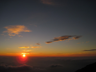 |
| Sunrise from Fuji |
In addition, given the crowding and partial queuing already in evidence at the lower, wider parts of the trail, we thought it'd actually be faster to climb in the morning. However, two of our group members didn't agree, one of them planning to get up at midnight to continue to the top and the other suddenly deciding to do the same without telling us. So in the end, our group was reduced to two.
 |
| Surviving group member |
As you can see, the main question about whether or not you're going to get a good view of the sunrise or not is what the cloud cover is relative to you. A partial sea of clouds somewhere below you is ideal, so that features on the surface are also visible.
At this part of the trail, the mountain itself is quite bare, and under the morning sunlight, it presents a rather Martian landscape.
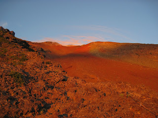 |
| The north-east face of Fuji |
Nevertheless the temperature was not very high. We managed to reach the crater in around 4 hours, and the going was not very tough. Sometimes you had to take large steps to climb bits of rock and use hands for balance. Carrying 4l of water made for a heavy pack. I think I might have felt the lack of oxygen after 3500m, but I was never actually short of breath. We actually climbed at a very even pace of 250m / hour, mainly to reduce the chances of altitude sickness.
For the more photographically keen among you, here are two shots of the same mountain range at dawn (4:30) and later in the morning.
Anyway, we made it to the crater at a reasonable time; it was quite windy there, so an extra layer was necessary. The views from the top were nice.
 |
| Kita... I think |
 |
| Crater porn |
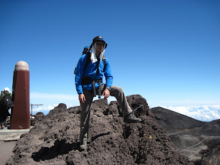 |
| Me? |
 |
| Sand run |
We went down the Subashiri trail, which is easier as it's a 'sand run'. You have to descent to 2000 rather than 2400m, but it takes about the same time. The main problem, of course is that darned sand. It seems to have embedded itself in my boots. Towards the end, the trail enters some greenery, which is a welcome change from the dreary blackness of everything else. However, there are very few stations on the downhill portion of this trail, so make sure to stock up on water, and the ones that are there are expensive. The cheapest one is a small shed at 2350m offering water for 600 yen / l.

Water: I had 3l with me, but I consumed 1l of water just getting to the bus stop, so I bought an extra liter there. Total 4. Then I also drunk nearly another liter while in the bus and while in the hut, which was warmer than I expected. So I bought another liter plus a coffee. The water consumption was overall not very high during the actual hike, but you should not forget to account for water use elsewhere in the schedule, as buying water on the trail is quite expensive (up to 1000 yen per liter). The temperature was not actually high during the climb itself, and it only got really hot while descending.
Overall, I recommend staying at a hut overnight, waking up just before dawn to relax with a coffee and starting early to get to the top before noon. There is little to gain by climbing up in the middle of the night. I also noticed that most of the people that were doing that were foreigners, while the Japanese seemed to prefer to follow the schedule that we did.


